The Basement Laboratory
In the basement of Columbia University's Lamont Geological Observatory, a woman sat hunched over a drafting table, surrounded by mountains of data that most people would consider incomprehensible. Numbers representing ocean depths, sonar readings from ships she'd never been allowed to board, measurements taken by men who barely acknowledged her existence.
 Photo: Columbia University's Lamont Geological Observatory, via lamont.columbia.edu
Marie Tharp was supposed to be invisible. In 1952, women weren't permitted on research vessels—bad luck, according to maritime tradition. So while her male colleagues sailed the Atlantic gathering data about the ocean floor, Tharp remained landlocked, transforming their raw numbers into something no human had ever seen: a detailed map of the world beneath the waves.
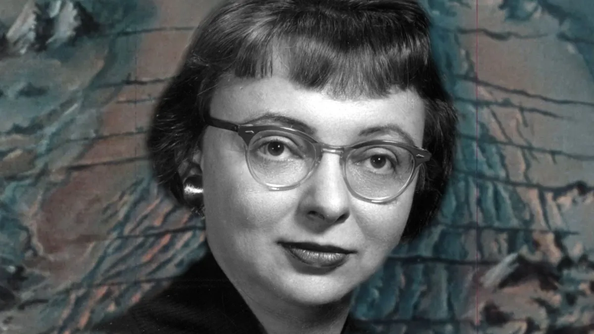 Photo: Marie Tharp, via cdn.britannica.com
What she discovered there would shake geology to its core.
The Girl Who Drew Mountains
Tharp's path to that basement laboratory had been anything but conventional. Born in 1918 in Michigan, she grew up following her father, a soil surveyor, around the Midwest. While other girls played with dolls, Marie learned to read topographic maps and understand how land reveals its secrets to those who know how to look.
Her father's work taught her something crucial: the Earth's surface tells stories, but you have to learn its language to understand what it's saying. Every hill and valley, every ridge and depression represents forces that shaped the planet over millions of years.
When World War II created opportunities for women in previously male-dominated fields, Tharp seized her chance. She earned degrees in geology and mathematics, then found herself at Columbia working with Bruce Heezen, a marine geologist who needed someone to organize and interpret the data flooding in from new sonar technology.
Listening to the Ocean's Secrets
The partnership was perfect, if unconventional. Heezen could go to sea and gather data, but he lacked Tharp's gift for visualization and pattern recognition. Tharp could see relationships in numbers that others missed, but she was barred from the ships where the most interesting discoveries were happening.
So they developed an unusual collaboration: Heezen would bring back sonar readings and depth measurements, and Tharp would transform them into detailed topographic maps of the ocean floor. It was painstaking work, requiring her to interpolate between sparse data points and use her understanding of geological processes to fill in the gaps.
As Tharp worked, something extraordinary began to emerge from her calculations. The ocean floor wasn't the flat, featureless plain that most scientists expected. Instead, it was a landscape as varied and dramatic as any mountain range on land, complete with valleys deeper than the Grand Canyon and ridges that stretched across entire ocean basins.
The Discovery That Shook the Earth
In 1952, while mapping the Mid-Atlantic Ridge, Tharp noticed something that made her heart race. Running down the center of the underwater mountain range was a deep valley—a rift that suggested the seafloor was being pulled apart.
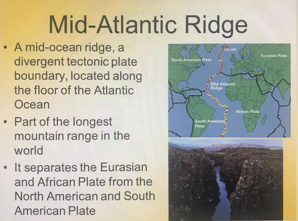 Photo: Mid-Atlantic Ridge, via i.pinimg.com
She knew immediately what this meant, even if she could barely believe it. The rift valley was evidence of seafloor spreading, a process that would support Alfred Wegener's controversial theory of continental drift. If new ocean floor was being created at these underwater ridges, it meant the Earth's surface was constantly changing, that continents could indeed drift across the planet over geological time.
When Tharp showed her findings to Heezen, his response was swift and dismissive: "Girl talk." The idea was too radical, too different from accepted scientific wisdom. Surely she had made an error in her calculations.
Fighting for Recognition
But Tharp knew what she had seen. She continued mapping, extending her work beyond the Atlantic to other ocean basins. Everywhere she looked, she found the same pattern: underwater mountain ranges marked by central rift valleys, evidence of a planet that was still growing and changing.
Slowly, as more data accumulated, Heezen began to see what Tharp had recognized years earlier. Her maps weren't just accurate—they were revolutionary. They provided the visual evidence needed to support plate tectonic theory, fundamentally changing how scientists understood the Earth.
Yet when the discoveries were published, Tharp's name often appeared in small print, if at all. The maps that required her unique combination of mathematical skill and geological intuition were frequently credited to the men who had collected the raw data, not the woman who had transformed numbers into knowledge.
The Art of Scientific Truth
Tharp's maps were more than scientific documents—they were works of art that made the invisible visible. Her hand-drawn illustrations of the ocean floor combined rigorous accuracy with aesthetic beauty, helping people understand that the deep sea was as geographically complex as any landscape on land.
Her most famous creation, a map of the entire Atlantic Ocean floor published in 1977, became one of the most influential scientific illustrations ever created. It showed the Mid-Atlantic Ridge in stunning detail, complete with the rift valley that provided evidence for seafloor spreading.
The map was so compelling that it appeared in classrooms around the world, helping generations of students visualize concepts that had previously been purely theoretical. Tharp had literally drawn the foundation for modern geology.
Recognition at Last
It took decades for the scientific community to fully acknowledge Tharp's contributions. As plate tectonic theory gained acceptance and her maps proved increasingly accurate, her role in one of geology's greatest revolutions became impossible to ignore.
In her later years, Tharp received numerous awards and honors, including recognition from the National Geographic Society and the Geological Society of America. But perhaps the greatest vindication came from technology: when satellites and deep-sea submersibles finally provided direct observations of the ocean floor, they confirmed that Tharp's hand-drawn maps were remarkably accurate.
The View From the Basement
Marie Tharp never set foot on a research vessel during her most productive years, but she traveled farther than any of her seagoing colleagues. From her basement laboratory, she explored every ocean basin on Earth, mapping territories that no human had ever seen.
Her story reminds us that sometimes the most important journeys happen not in exotic locations, but in quiet rooms where patient minds work to understand complex data. Tharp proved that you don't need to go to sea to discover new worlds—sometimes you just need to know how to listen to the stories that numbers tell.
In a field dominated by men with access to ships and equipment, one woman with a drafting table and an extraordinary mind changed everything. She drew the invisible world beneath the waves and, in doing so, redrew our understanding of the planet itself.